Entradas

Mostrando entradas de abril, 2021

ROUTE 1 WAYPOINT 23

Imagen
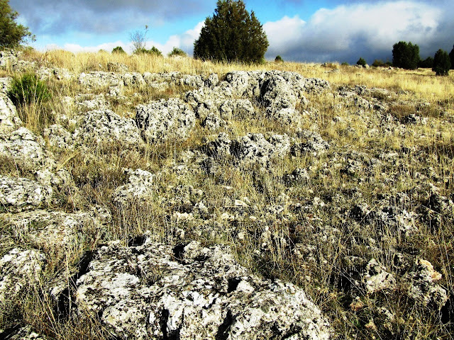
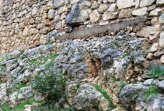
  Waypoint 23: Quarry with crossed layering  Map route 1 After going through a zone with low outcrops, we find an old quarry where it stands out something that every geologist get impressed with; we find a crossed stratification which is specially marked in the chalky rocks. This is something quite uncommon as carbonatic rocks do not tend to have a good quality for sedimentary structure outcrops. This is due to the extraordinary conservation of the outcrop and because of its composition of small fossil fragments that resembles sandstone. This chalky rock is part of the first carbonatic bar, the crossed stratification its a reflection of the progress of a submarine bar associated with water currents, so in this case we have the proof that we are in an immersed bar that moves due to different currents. Photo interpretation: The black lines are different stratigraphical and/or mining surfaces that prevent the observation. Red lines is the crossed stratification. Image taken by Dubin D.M (

ROUTE 1 WAYPOINT 8 bis AND ROUTE 2 WAYPOINT 5

Imagen
  Waypoint 8: Decorative blocks with rudists  Map route 1   (Map Route 2) At the start of the road and Mirador de la Peña street , this decorative blocks are found with abundant rudist outcrops. Traditionally these rocks have been used to build the village and here we find a clear example of it. 1) View of Hippurites incisus from a perpendicular section. It is easy to appreciate the characteristic shell with two inner pillars really outstanding and a small joining crest. 2) Block with abundant Hippurites incisus 3) Block where it is easy to see the shell of Biradiolites angulosus, with their characteristic folded sheets.

ROUTE 1 WAYPOINT 22

Imagen
 Waypoint 22: The wineries path  Map route 1 Here we find the lower part of the second bar, and excaved in the soft section between both parts of the bar are the wineries, the use as a ceiling the upper carbonatic unit. Many of these wineries have a small pic nic area at the front of the winery. The wineries are usually of shallow depth, with a small slip and a bigger zone that is were wine is stored. Here barrels are stored, usually at the sides in rows.

ROUTE 1 WAYPOINT 21

Imagen
Waypoint 21: The sinuous stairs  Map route 1 After the route, in the way back, we descend to the stream through stairs that have isolated rocky outcrops, that with the outcrops that we have in front of us let us define de type of rocks we find and its relation with what we have been watching, we are in the upper part of the second bar.

ROUTE 1 WAYPOINT 20

Imagen
Waypoint 20: The winepress  Map route 1 Moving a little bit away from geology, we cannot ignore the ethnological patrimony of the village. In the depths of the valley and on the fertile zones of the surroundings vines are cultivated, when grapes are collected, then they are pressed and wine is made. This winepress belonged to 4 different families, each one owned of one of the corners, the introduced the grapes and then received the wine in the proportion of the grapes given. Through the windows they dropped the grapes (after weighing them) that were carried in wicker basquets into the upper tank and there they stepped it.The used a wooden structure that was positioned between the grapes and the upper big woods with a worm screw anchored with a big chalky boulder that pushed enough to get the juice of the fruit which passed to the lower tank. After all it was transported to the wineries. Depending on the amount of grapes delivered, they received the proportional part in bulk tanks of gr

ROUTE 1 WAYPOINT 18

Imagen
Waypoint 18: Viewpoint of the antenna  Map route 1 From this point we have a panoramic view of the village where we can see the relationship between the different limestone units. We can see the close relationship between the village of Castrojimeno and the limestone, as the village has used these rocks to settle, and the valleys formed by the reguero and the Hoceca, which shape the village, giving it its particular area and defining the central nucleus of the village; towards the reguero the area of vegetable gardens and in the Hoceca the area with wine cellars. On the other hand, at this point is the antenna that supplies the village with mobile phone and television networks.

ROUTE 1 WAYPOINT 19

Imagen
 Waypoint 19: Oakum fields.  Map route 1 From here we can turn our point of view and see Castrojimeno from above, we see the villages' shape and how it has been built around the shape of the environment and is severly conditioned due to it. This spot similar to the steppe, covered with low grasses like pasturage and a few juniper trees is called in Castrojimeno "Estopar

ROUTE 1 WAYPOINT 17

Imagen
Waypoint 17: The upper area  Map route 1 We reach the highest point in the route, at 1090 metres. Here we can appreciate how the rocks flourish nearby. We cannot see any fossils or even structures, we just see the dilution of carbonatic rocks due to waterflow. It is also remarkable the absence of vegetation due to agricultural and cattle farming in this zone. In the surroundings you can see rock fences that have been built with rocks of the area, this is because traditionally, these fields were cultivated even though they were quite rocky, which implied that first it had to be cleaned and pulled of as the field was ploughed.

ROUTE 1 WAYPOINT 16

Imagen
 Waypoint 16: Panoramic view  Map route 1 From this waypoint and during the route we can exploit that we are in the most elevated zone to take a panoramic view of our surroundings. At this moment, chalky stone is mostly camouflaged due to tertiary sediments that are on top of it and partially eroded the chalky rocks and the dolomites we have been watching until now. On the one hand, southeastly we have the "Alto de Fuentemilanos", the setting of "Peñatraviesa" and the "Umbría de las duernas". In the distance, we have a sea of pines that it extends dozens of kilometres up to Avila and Valladolid. These forests are really typical of Segovia. During clear days we can even see the highlands of Ayllon, Guadarrama and Gredos. The surrounding mountains that border the south area of north subplateau, this is because we are currently in a quite high zone surrounded by a series of creases by the alpine orogeny that create the Pradales highland and the Sepulveda one

RUTA 3 PUNTO 5

Imagen
Punto 5. La canal de lavar y los bebederos  (Plano Ruta 3) Bajando al Arroyo de la Fuente del Prado o fuente Grande y tras haber pasado La Puentecilla y dejado a la izquierda Los Colmenares, se llega a la parte alta de La Canal, lugar donde se lavaba la ropa y cogía agua para la población cuando no estaba metida el agua en las viviendas. Un poco más arriba había dos pilas de piedra, ( actualmente sirven de jardineras junto a la Asociación y en la plaza del Empedrado) donde bebían las caballerias cuando venían del campo de trabajar. Llama la atención una roca con una estratificación cruzada muy marcada. La estratificación cruzada es una estructura interna debido al origen sedimentario de las rocas y que se relaciona con el movimiento de corrientes (normalmente agua) y que genera estructuras llamadas Ripples o dunas submarinas que van moviéndose gracias a las corrientes.

RUTA 2 PUNTO 1

Imagen
Punto 1: Bloque de rudistas frente a la Asociación  (Plano Ruta 2) Se trata de un bloque perteneciente a la segunda barra y completamente lleno de  rudistas (especialmente Hippurites incisus y algún  Biradiolites angulosus). Curiosamente, sobre este punto debe haber estos mismos rudistas, el problema es que la urbanización de la Villa, no nos permite apreciarlo. En este caso, en términos geológicos, son rudistas pertenecientes a la segunda mitad de la barra calcárea de la Formación Hortezuelos, en el tramo donde abundan los Hippurites incisus, frente a los Radiolites . Esto se debe a que los Hippurites tienen un crecimiento más rápido y están ocupando casi la totalidad del espacio.

ROUTE 1 WAYPOINT 1 AND ROUTE 3 WAYPOINT 18

Imagen
Waypoint 1: The initial loam soils  (Map route 1)   (Map route 3) Here you can find the first soft units of the sedimentary sequence that forms DS-2. This unit represents up to the first layers, that highlight the TST tract, in other words, the Transgresive tract, associated to a quick rise in the sea level which produces marine-based rocks from a relatively deep level. The first hard unit that gives a slightly greater protrusion represents the maximum flood surface (MFS). From this level on the rate of increase in the sea level decelerates being compensated with the sedimentary contribution until the high sea level tract (HST) is started. Paleontologically speaking, in this unit, oversize ostreidae stand out, with a lower, very heavy shell that enables them to stabilize in the substrate. After the death of the organism, it is usually colonised by sponges and serpulidae. Furthermore, it is also frequent to find ammonites like Iberian priocycloceras , Tissotia Sp., Celtiberian hemitisot

ROUTE 1 WAYPOINT 15

Imagen
  Waypoint 15: The chalky rock stairs  Map route 1 We keep on ascending and find one of the small whims of geology. If we add the erosion and dilution of dolomies, as well as the strata of low power in this zone of the Montejo dolomite unir, it generates a stair like structure of chalky rock. What's interesting is that this process is completely natural and even thoug it seems like the stairs are man-maed and carved in the stone, its' nature who has built them.

ROUTE 1 WAYPOINT 14

Imagen
 Waypoint 14: A cave thanks to a fault  Map route 1 Inside this same unit we find a cave with a peculiar triangular shape, with one of its' sides really flat. It is a small inverted fault with a movement of a few centimetres. These faults of small size are easy to see, differently to the bigger one that generate big movements which are produce a big deformation making it difficult to see. It is outstanding that if we enter the cave, the flat wall has a slightly different colour, with a little glow, this is called fault mirror. When the rock moves during earthquakes, sand grains file and polish the break zone, in some cases (not here) it can causa an increase of the temperature and even a partial meltdown. The different grains and the faults' movement generate grooves and even small steps that help us deduct the movement of the fault.

ROUTE 1 WAYPOINT 13

Imagen
 Waypoint 13: The sickles' cannon  Map route 1 After crossing the small stream, we see how dolomites start to form a big cannon with cliffs of several dozens of metres. The origin of this is simple, the dolomites that we find are mostly homogeneous, without intercalations of other types of rocks ( as loams in the formation of "hortezuelos"). The presence of an stream with water all year long is what, as time passed by, diluted rock and formed this cannon. However, it is not completely homogeneous, we encounter more altered levels, with more nodes which are associated to periods with more activity and bioturbation of the sediments. This rocks with so many nodes are softer, this generates small holes and slumps, making of it an ideal environment for the nesting site of griffon vultures.

ROUTE 1 WAYPOINT 12

Imagen
  Waypoint 12: The meeting point rock      Map route 1 As we move on, we continue with the unit of Dolomites of Montejo. Here wwe can see similarities with waypoint 3 but increased in magnitude. If we saw previously eroded ground and diluted by water, here the effect is larger, generating big, well-formed exokarstic structures. It is outstanding the rock just in front of us, the meeting point rock, symbol of Castrojimeno. Here two paths meet (right and left) and that continue in the path we have been following until this point. This structure called "Tor" has remained isolated, even though a few metres away we can find similar structure of smaller size. It represents an isolated block of the large dolomitic unit were we find ourselves. Another curious fact is that if we take notice of the position of the strata, they are slightly tilted, more than the rest, which determines that this is possibly a dumped block or partially rotated.

RUTA 3 PUNTO 7

Imagen
  Punto 7. Hornachos o cuevas pequeñas  (Plano Ruta 3) Por el camino que acompaña al Arroyo proliferan las cuevas hornachos, o cuevas pequeñas que servían para guarecerse de las inclemencias del tiempo a pastores transeúntes. El proceso es similar a lo que formaba las anteriores cuevas, pero posiblemente se asocie aquí también a la presencia de aguas subterráneas que poco a poco disuelven el macizo calcáreo además de procesos de desprendimientos. Por esta zona también se han llegado a encontrar una necrópolis que se ha datado a mediados del Siglo XIII, posiblemente a consecuencia de alguna batalla de la época .

RUTA 2 PUNTO 15

Imagen
Punto 15. Casa La panera también sobre el Arrecife  (Plano Ruta 2) Acabamos este recorrido con otro ejemplo donde podemos ver, como esta casa, que fue La Panera donde se recogían los Diezmos y primicias eclesiásticas , se asienta directamente en la roca del Arrecife que formaba bancadas, lo que configura la posición en altibajos de las viviendas.

RUTA 2 PUNTO 14

Imagen
  Punto 14.  Callejón del Ayuntamiento  (Plano Ruta 2) Aquí e el centro del pueblo, en este rincón sin urbanizar, vemos como toda la localidad está asentada sobre este arrecife de rudistas , en esta caso Hippurites incisus en posición de vida. Quien gobernó hace 80 millones de años, se sitúa a pocos metros del que hoy es edifico del órgano de gobierno de la actual población. En Castrojimeno el pasado y el presente van de la mano, ligando el avance a este patrimonio que durante tantos millones de años, marcó el entorno y que hoy en día se pretende por en valor, como un antepasado mas que  marca las raíces de esta población.

RUTA 2 PUNTO 13

Imagen
 P unto 13.  Rudistas sueltos y horno   (Plano Ruta 2) Siguiendo el camino hacia el pueblo, atravesamos de nuevo el arrecife, esta vez la erosión ha permitido que se conserven mejor algunos fósiles. Podemos ver ahora abundantes Radiolites cortados en sección con el interior de su concha vacía, la marcada forma cónica y podemos intuir la concha externa en forma de “falda de gitana” Castrojimeno tiene un patrimonio geológico con una riqueza excepcional, debido al excelente estado de conservación de sus fósiles y la utilidad del registro sedimentario en su conjunto para la interpretación paleoambiental e incluso secuencial. Es decir no tan solo los fósiles si no que todos los sedimentos y elementos geológicos del entorno (y la relación con otros circundantes) permiten analizar diferentes oscilaciones del nivel del mar e incluso conocer cambios en el clima hace 80 millones de años (Gil et al., 2009; García-Hidalgo et al., 2012; Gil et al., 2012; Font et al., 2013…) lo que hacen de Castroji

RUTA 2 PUNTO 12

Imagen
  Punto 12. Que las plantas no te impidan ver el arrecife.  (Plano Ruta 2) Toda la Villa de Castrojimeno está asentada en su mayor parte sobre la bioconstrucción. Si en el extremo norte del pueblo puntos 3-4 y 5, teníamos el arrecife, ahora en su opuesto tenemos lo mismo. Sin embargo, si en los otros puntos la urbanización había creado unas condiciones de afloramiento idóneas, ahora tenemos las rocas en su aspecto mas natural, en este punto destacan los Radiolites Sauvagesis , aunque también encontramos Hippurites y Biradiolites. Es llamativo ver como estos rudistas , actúan a veces casi como macetas, al ser pequeños agujeros se llenan de tierra y favorecen que las semillas de las plantas germinen; el problema de esto es que favorecen la erosión de los fósiles.

RUTA 2 PUNTO 11

Imagen
  Punto 11. "Tapiología" la geología y su entorno  (Plano Ruta 2) Este muro se ha construido utilizando diferentes rocas de su entorno, podemos prácticamente indicar de forma clara, donde ha salido todas o casi todas las rocas que lo forman. Si miramos en detalle vemos varias rocas con los ya clásicos rudistas , (estos tubos o agujeros circulares en las rocas). Encontramos aquí rudistas de diverso origen y tipología, que nos permite hacer un repaso por la paleontología regional. 1) Hippurites incisus: caracterizado por su morfología irregular con dos tabiques muy marcados en la concha lo que genera dos grandes arrugas en el espacio interior. 2) Biradiolites canalictus : de diámetro más bien fino y largos, destacan por no tener esos pilares interiores, y sin embargo tienen una concha muy gruesa y redoblada. 3) Radiolites sauvagesi : de diámetro grueso sin pilares interiores, y concha muy gruesa con diferentes laminas que se superponen; lo que da una apariencia externa de &qu

RUTA 2 PUNTO 8

Imagen
  Punto 8. Bloques de rudistas junto a la iglesia.  (Plano Ruta 2) De nuevo encontramos nuevos bloques de rudistas para decorar diferentes puntos de la Villa de Castrojimeno. 1) Bloque que contiene abundantes Radiolites sauvagesi , aunque muchos de ellos se encuentran en posición invertida o fragmentados. 2) Bloque donde se observa claramente una agrupación de Biradiolites angulosus en racimo (Thicket). El resto de oquedades de la roca se debe a la disolución de la caliza. 3) Se trata de un afloramiento donde apreciamos en la parte superior un gran Radiolites sauvagesi y el resto formado fundamentalmente por Biradiolites angulosus.